Wilderness in Your Pocket: Southwest Indian Country

Wilderness in Your Pocket_ Southwest Indian Country

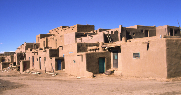
The Southwest area generally extends over Arizona, New Mexico, as well as parts of Colorado and Utah. The first humans to inhabit the Americas are presumed to have moved from N.E. Asia across a land bridge, known as Beringia, exposed in the Bering Sea region several times during the Ice…

A Wine Tasting Trip Along the California Coast

A Wine Tasting Trip Along the California Coast

Ahh … a relaxing weekend just you and your spouse or just the girls. Where will you go? What will you do? Ever think about taking a drive along the California Coast and visiting the wineries? We have the perfect map for you, Califonia Wine Country. Want to sound like…

Think Outside the Device and Get a Real Map

Think Outside the Device and Get a Real Map

Okay, let’s think “outside the box here”, that box-like electronic device. Our dependence on cell phones, computers, tablets and navigation systems begs the question: what did we do before all these toys? In the case of travel planning, we looked at maps before going off on our journey. This may…

Travel to the San Francisco Bay Area

Travel to the San Francisco Bay Area

As a tourist, to understand the City of San Francisco use the SAN FRANCISCO BAY AREA MAP to see San Francisco in its context on the Peninsula. The terrain of the region is versatile, with many views of the Bay from the hills to the north and east of San…

Travel to the Beautiful City of San Francisco

Travel to the Beautiful City of San Francisco

The City of San Francisco is unique and wonderful. Blessed with a temperate climate and set on naturally beautiful terrain surrounded on three sides by water. The topography of its many hills offers splendid vistas. Views of the Pacific Ocean from the beaches, views from Twin Peaks over the City or…

U.S. Route 66 – Main Street of America Part II

U.S. Route 66 – Main Street of America Part II

Continued from Part 1 1950’s: Postwar Boom As automobile and truck traffic increased, the businesses along U.S. Route 66 served the travelers’ needs. Service stations, restaurants, auto camps and cottages, later motels, sprang up, some of them in the most astonishing architectural styles – restaurants in the form of a…

U.S. Route 66 – Main Street of America

U.S. Route 66 - Main Street of America

Do you want to go back to the road’s very beginnings? Or experience somewhere along the way at a diner, in an “oldies” car, or perhaps in a teepee? Find out what the road was, from Steinbeck’s to Bobby Troop’s vision of it. Weathered, withered, wondrous: the Okie’s ‘glory road’….

Tour Napa Valley Wineries: A Wine Primer

Tour Napa Valley Wineries- A Wine Primer

Think of taking a leisurely drive along the California Coast and visiting Napa Valley wineries? Wine tasting can be a relaxing way to spend a weekend. We carry several maps of California, Oregon, and Washington Wineries. Here’s a primer to what you’ll learn during your wine tour: Nose NOSE includes aroma…

Napa Wine Country, Sonoma Wine Country

Napa Wine Country, Sonoma Wine Country

Around the world, Napa wine country is certainly most known for being “wine country” for the entire United States. California’s wine comes out in the top tier of wines internationally. This has been true since 1976 when California wine started winning international awards. Year after year the epitome of quality…

Read a Street Map: Your Sense of Direction

street map of san diego

You have good spatial recognition, or maybe you don’t. For example, you happen to be in San Diego. Do you go out of your hotel room heading toward the elevator and go off in the wrong direction? Do you open a street map and feel fairly overwhelmed, fold it back…

Large Print Maps at GM Johnson

At GM Johnson Maps we are starting to create more large print maps. You can see our Washington / Oregon Coast Large Print Map in action (In use by some early 20 year old road trippers in Oregon): Our Washington and Oregon Coast Map is one of our best sellers, selling more…

Happy Holidays from Santa Guy

Santa Guy has two new map books in California. San Jose and San Francisco map books are now available for purchase. More information and page sample are available at the following pages: San Jose & Santa Clara Map Book San Francisco & San Mateo Map Book

New Website

This is our half-page ad for the IMIA trade show held in Denver Co, Nov 2-4, 2014. We have updated to a new website. New features include a shopping cart system and zoomify maps(view full map in detail) which you can check out by going to any product page. Also…

Download Map Covers & New Maps

Download Our Map Covers If you would like to download a ZIP package of all our map covers for your own promotions or marketing you can do so HERE. There is also a link on our product catalogue page to this ZIP file. We have added and updated a bunch of…

Napa and Sonoma Wine Country

To our many customers, suppliers and friends. We would like to introduce you to our newest map of Napa and Sonoma Wine Country. The map cartography is by Global Graphics, H.J. Hesse. The map includes wineries of Napa, Sonoma, Mendocino and Lake Counties California. The map has descriptive text on…

GMJ moves into Texas

We have our first map located in the state of Texas. A street map of Denton / Plano Texas which you can see here: Denton / Plano, Texas We also have worked on many other Texas maps for Rand McNally including: Austin (street) Dallas (street) Fort Worth (street) Houston (street)…

Santa Skiing and Happy Holidays

To our many Customers, Supplier and Friends. I would like to wish you a Happy Holiday season. Attached is a photo of me dressed as Santa. The first 75 Santa’s that show up before 8:00 AM ski free. There was about 150 that showed up. Whistler Mountain in their Christmas…

Check out our Puerto Rico map

GM Johnson has been creating the Puerto Rico map for AAA for a few years now. The new version has been re-branded with our cover design. Take a look here